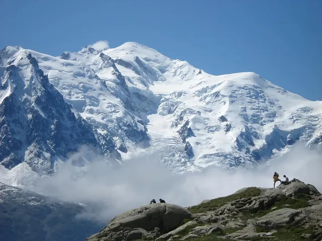
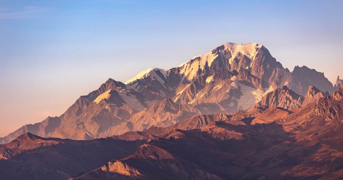
Search for what is a massif and page one hands you a stack of dictionary entries, each saying roughly the same twelve words, none of them showing you a mountain. That is a shame, because the word is doing real work. It is the reason a single skyline feature can carry six names, the reason the highest point of a famous mountain is often not the one in the photograph, and the reason two guidebooks can disagree about how many summits you are looking at.
A massif is a compact group of connected summits that share one base and behave as a single mountain mass. In structural geology the word also means a fault-bounded block of crust that stays rigid and is displaced as a unit while softer rock around it deforms. The Mont Blanc massif happens to be both at once.
Those two senses sound unrelated, and for a long time they were used by different professions. They converge more often than you would expect, and the convergence is what makes the word useful rather than decorative.
What is a massif in each of its two senses
The everyday sense comes straight from French, where massif means bulky or massive. Applied to terrain, it describes a mountain mass that hangs together: several summits rising from one shared base, separated from each other by cols rather than by valleys, and separated from the rest of the range by something obvious, usually a deep valley or a pass. You cross a valley to leave a massif. You only cross a saddle to move between its summits.
The geological sense is stricter. There, a massif is a section of the crust marked out by faults or flexures which keeps its internal structure intact while the terrain around it folds, stretches or thrusts. Massifs of this kind are often old, hard basement rock, granite and gneiss that predates the mountain-building event that lifted them. They can be enormous and not obviously mountainous at all: the Massif Central in France and the Bohemian Massif in central Europe are crustal blocks first and scenery second.
The two senses meet whenever a rigid block gets lifted intact and then carved by glaciers, because a block resists erosion as a unit and ends up as a cluster of steep summits standing apart from everything else. That is exactly the story of the Alps’ external crystalline massifs, which is where the best worked example lives.
The Mont Blanc massif: one name, eleven independent summits
Mont Blanc is a summit. The Mont Blanc massif is the roughly 46 km block of granite it sits on, stretching across the borders of France, Italy and Switzerland. Calling the whole thing “Mont Blanc” is the single most common naming error in the Alps, and once you see the difference the range stops being confusing.
The massif contains eleven independent summits over 4,000 m plus six subsidiary points above that line. Mont Maudit reaches 4,465 m (14,649 ft), Mont Blanc du Tacul 4,248 m (13,937 ft), the Grandes Jorasses 4,208 m (13,806 ft), the Aiguille Verte 4,122 m (13,524 ft) and the Dent du Géant 4,013 m (13,166 ft). Mont Blanc itself, just over 4,800 m, is re-surveyed every couple of years because its summit is a snow dome rather than rock, so the official figure genuinely moves.
Now the part that matters for identification. The peak most people photograph from Chamonix, the needle with the cable car station on top, is the Aiguille du Midi at 3,842 m (12,605 ft). It is not a 4,000 m peak, it is not the highest thing in view, and it is not Mont Blanc. It simply stands closer to town and looks more like what a mountain is supposed to look like. Mont Blanc, being a rounded white dome set further back, reads as less dramatic than several of its own neighbours despite being the highest ground in western Europe.
Geologically the same block is a textbook external crystalline massif: ancient granite in the outer zone of the Alps, bounded by valleys that formed along fault lines, pushed up as a coherent unit. One name, two definitions, no contradiction.
Annapurna: a massif where the highest peak hides
The Annapurna massif in Nepal makes the point at a larger scale. It runs about 55 km, bounded by the Kali Gandaki Gorge to the west, the Marsyangdi River to the north and east, and the Pokhara Valley to the south. Those boundaries are what make it a massif rather than an arbitrary slice of the Himalaya: it has edges you could walk to.
Inside those edges sit Annapurna I at 8,091 m (26,545 ft), the tenth-highest mountain on Earth, along with Annapurna II at 7,937 m (26,040 ft), Annapurna III at 7,555 m (24,787 ft), Annapurna IV at 7,525 m (24,688 ft), Gangapurna at 7,455 m (24,459 ft) and Machapuchare at 6,993 m (22,943 ft). Standard descriptions of the massif count one summit above 8,000 m, thirteen above 7,000 m and sixteen more above 6,000 m.
Here is the identification trap. From Pokhara, the town almost every visitor sees the massif from, the peak that dominates the view is Machapuchare, the fishtail summit that is not even close to being the highest in the group. Annapurna I sits set back behind nearer, lower summits and is not the shape anyone remembers. Photographs captioned “Annapurna” are, more often than not, of something else in the Annapurna massif. The caption is not wrong exactly, which is precisely the problem.
Vinson: the case where the naming was formally split
Antarctica supplies the cleanest example of what changes when you call something a massif. For decades, the continent’s high point was known as Vinson Massif, in the Sentinel Range of the Ellsworth Mountains, and there was no separate name for its summit. The bulk was the name.
Climbers, unsurprisingly, wanted a name for the top rather than the block, and usage drifted toward “Mount Vinson”. In 2006 the US Advisory Committee on Antarctic Names made the split official: Mount Vinson is the highest summit, at 4,892 m (16,050 ft), and Vinson Massif is the larger feature that contains it. It was first climbed in 1966 by an American team led by Nicholas Clinch, and it is named for Carl Vinson, the Georgia congressman who pushed for American work in Antarctica.
That one decision is the whole distinction in miniature. Before 2006, asking “how tall is Vinson Massif” meant asking about a landform with several high points. After 2006 it meant asking about a specific summit. Nothing on the ice changed. The nomenclature did. Anyone assembling a Seven Summits list has to pick a side of that split, and older lists and newer lists do not always agree.
Massif, range, subpeak: how prominence decides who gets a name
Three words sit on a spectrum of scale, and the confusion is almost always about which one applies.
A range is a linear chain, usually tens or hundreds of kilometres long, built by one mountain-building episode and containing many separate massifs. A massif is compact: one base, several summits, hard boundaries. A subpeak is a high point on a massif that does not qualify as its own mountain.
What decides that last call is prominence, the drop from a summit to the lowest col you must cross to reach higher ground. The Alps have a formal version of this rule. When the UIAA published its list of the Alpine 4,000 m peaks in 1994, the primary criterion was a prominence of at least 30 m above the highest adjacent col, adjusted by judgment about a summit’s overall shape and mountaineering significance. That produced 82 official summits, plus a separate table of 46 subsidiary points that cleared 4,000 m but were ruled to be parts of other mountains rather than mountains in their own right.
Thirty metres is a low bar and a deliberate one: in a massif, summits are close together and cols are high, so prominence values are small and the threshold has to be small too. The same logic in a different register runs through what actually makes a separate mountain, and the underlying number gets a full treatment in elevation vs prominence. A companion measure, topographic isolation, does the horizontal version of the same job, and it collapses inside a massif for the same reason: everything is near everything else.
Why a massif is the hardest thing to name from a distance
Put the pieces together and a massif is close to a worst case for skyline identification, for four reasons that stack.
Its outline changes completely with viewing angle. Summits that stand clearly apart from the south merge into one ridge from the west, so the number of peaks you can count is a function of where you parked.
Its highest point is frequently invisible. Massifs are deep, and the tallest summit tends to sit in the middle, screened by nearer, lower, steeper neighbours that catch the eye first.
Its names attach at three scales at once. The same word can mean the block, the highest summit, or the peak nearest the valley people live in, and casual usage does not distinguish.
And its most photogenic peak is usually not its high point. The Aiguille du Midi and Machapuchare both prove it: sharpness reads as height, and the eye rewards drama over elevation every time.
That is why the honest answer to “which mountain is that” is often “that one, in this massif, and the highest thing in front of you is actually behind it.” Point a camera at the skyline and you can get the summit name, its elevation, its prominence and the range it belongs to, which is the difference between recognising a shape and knowing what you are looking at.
The real peaks
Genuine photographs of the summits above — so you know what to actually look for: