Ask “what’s the tallest mountain on Earth?” and you’ll get Everest, obviously. But ask for the tallest mountain base to summit — the biggest wall of mountain actually rising in front of you — and Everest quietly drops to third place, behind a peak in Alaska and a volcano mostly hiding under the Pacific.
“Tallest” hides three different measurements. Highest above sea level: Mount Everest, at 8,848.86 m (29,031.7 ft). Greatest base-to-summit rise on land: Denali, climbing roughly 5,500 m (18,000 ft) from its surrounding lowlands. Tallest including terrain below the sea: Mauna Kea in Hawaii, about 10,200 m (33,500 ft) from seafloor to summit. Each answer is correct — for its own ruler.
Here’s how the three rulers work, and why the podium reshuffles so dramatically depending on which one you pick.
Ruler one: elevation above sea level
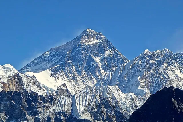
This is the number everyone knows. Elevation measures the summit’s height above mean sea level, and by that ruler Mount Everest is untouchable: 8,848.86 m (29,031.7 ft), the figure Nepal and China jointly announced after their 2020 survey. No other point of rock on the planet stands higher into the atmosphere.
Elevation is the right ruler for some very real questions — how thin the air is, how cold it gets, how high aircraft must fly to clear it. But it tells you nothing about how much mountain is actually there, because it doesn’t care where the mountain starts.
Ruler two: base to summit on land — where Denali wins
And that’s the catch with Everest: it starts remarkably high. The mountain rises from the edge of the Tibetan Plateau, terrain that is already at extreme altitude — Everest’s base camps themselves sit at around 5,150 m (16,900 ft) on the Tibetan side and 5,364 m (17,598 ft) on the Nepali side. Stand at the northern base camp and the summit towers about 3,500 m (11,500 ft) above you. Enormous — but not the biggest such view on Earth.
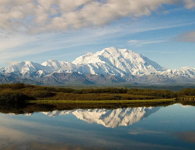
Denali is. Its summit elevation is a comparatively modest 6,190 m (20,310 ft), but the land around it isn’t a lofty plateau — it’s low tundra and glacial valleys not far above sea level in places. The result is a base-to-summit rise of roughly 5,500 m (18,000 ft), commonly cited as the greatest of any mountain standing entirely on land. Face Denali from the north and nearly the whole mountain is stacked in front of you, one uninterrupted wall from tundra to summit ice.
This is why seasoned travelers often say Denali looks bigger than Everest, and they’re not being contrarian — by the ruler your eyes actually use, it is. Your eyes don’t measure altitude above a sea thousands of kilometres away; they measure the sweep of terrain from where the mountain visibly begins to where it tops out.
One honest caveat: “base” is a fuzzier concept than “summit.” A summit is a point; a base is a judgment call about where surrounding terrain stops and mountain begins, which is why base-to-peak figures are always rounded and why careful sources say “about 5,500 m” rather than pretending to single-metre precision.
Ruler three: base to summit including the seabed — Mauna Kea’s trump card
Now remove the “on land” restriction. Mauna Kea, the giant shield volcano on the island of Hawaii, reaches just 4,205 m (13,796 ft) above sea level — it wouldn’t crack any list of high peaks. But the mountain doesn’t start at the beach. It rises from the floor of the Pacific Ocean, and measured from that submarine base to its summit, Mauna Kea stands roughly 10,200 m (33,500 ft) tall — comfortably more than a kilometre taller than Everest by the same base-to-summit logic. Guinness World Records lists it as the world’s tallest mountain on exactly these grounds.
Most of that height is invisible, of course — well over half the mountain lies under the sea. Which is precisely the point: Mauna Kea is the extreme demonstration that “how high is the summit” and “how big is the mountain” are different questions.
The three rulers, side by side
Here’s the whole argument in one comparison:
- Highest summit above sea level: Everest — 8,848.86 m (29,031.7 ft). Mauna Kea reaches only 4,205 m (13,796 ft); Denali 6,190 m (20,310 ft).
- Greatest base-to-summit rise on land: Denali — about 5,500 m (18,000 ft) of visible mountain. Everest rises very roughly 3,500 m (11,500 ft) above its base-camp surroundings, because the Tibetan Plateau gives it a colossal head start.
- Greatest base-to-summit rise anywhere: Mauna Kea — roughly 10,200 m (33,500 ft), most of it below the Pacific.
Three questions, three champions, no contradiction.
Why this matters when you’re reading peak stats
Once you’ve internalized the three rulers, a lot of mountain trivia stops being confusing. “Denali is taller than Everest” and “Everest is the highest mountain on Earth” are both true. So is “the tallest mountain on Earth is mostly underwater.” People only end up arguing because they’re silently using different rulers.
It also changes how you read a skyline. A summit’s raw elevation is a poor predictor of how imposing it looks; what your eye responds to is local rise — how much mountain stands between the valley floor and the top. That’s closely related to a third statistic, prominence, which measures how independently a summit rises above everything around it; we’ve unpacked that in our guide to elevation vs prominence. High-local-rise, high-prominence peaks dominate their landscapes; high-elevation peaks sometimes hide in crowds of other giants.
When you identify a peak with the app, you get elevation and prominence side by side — and now you know why one number tells you how high the summit is, while the other tells you how much of the mountain you’re actually looking at. Everest owns the first ruler. Denali, magnificently, owns the view.
The real peaks
Genuine photographs of the summits above — so you know what to actually look for: