Ask how tall is Mont Blanc and you’ll find sources that say 4,810 m, others that say 4,808 m, and recent ones closer to 4,806 m. None of them are sloppy. The roof of the Alps genuinely changes height, and France re-measures it every two years to keep up — which makes Mont Blanc the rare famous mountain whose official number comes with a date attached.
How tall is Mont Blanc? The September 2025 survey measured the summit at about 4,807.3 m (15,772 ft), up from the record low of 4,805.59 m (15,766 ft) in 2023. The summit is a dome of snow and ice that grows and shrinks, so the official figure is re-measured every two years — while the rock beneath tops out near 4,792 m (15,722 ft).
A summit made of snow
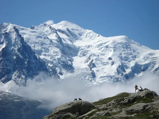
Most famous summits end in rock. Mont Blanc ends in ice: the top of the mountain is a smooth dome of compacted snow that the wind and weather reshape continuously. The underlying rock summit — measured at about 4,792 m (15,722 ft) — sits slightly to one side of the ice dome and never sees daylight in a normal year. What climbers stand on, and what surveyors measure, is the snow.
That has a strange consequence: the highest point of Western Europe is not fixed. The dome’s height depends on how much snow recent seasons deposited and how much summer heat stripped away, and its highest point even wanders several metres horizontally from survey to survey. The mountain itself — the rock — is essentially stable on any human timescale. The last few metres are weather.
The biennial measuring expedition
Since the early 2000s, a team of surveyors from Haute-Savoie has climbed Mont Blanc every two years in mid-September, carrying GPS receivers to map the dome precisely — with an accuracy of a few centimetres. September matters: it’s the end of the ablation season, after summer melt and before the autumn snows, so each survey catches the mountain at a comparable moment.
The results wobble in a band a few metres wide. Recent campaigns reported by the surveyors and local press include 4,810.90 m in 2007 near the top of the range, 4,808.72 m in 2017, 4,807.81 m in 2021, then a headline-making drop to 4,805.59 m (15,766 ft) in 2023 — the lowest figure in the survey era, announced after exceptionally dry, hot seasons in the western Alps. The September 2025 measurement recovered to about 4,807.3 m (15,772 ft). A rise, after two years of “Mont Blanc is shrinking” headlines.
The surveyors themselves are careful about what this means: a two-metre swing in the snow dome is weather and snowfall variability, not a direct climate verdict in either direction. The signal worth watching is the long series, not any single expedition — which is exactly why they keep climbing up there every other September.
How tall is Mont Blanc: which number to use
It depends what you’re asking. If you want the mountain — the thing that will still be there in a thousand years — the rock summit around 4,792 m (15,722 ft) is the honest answer. If you want the highest point you could stand on, quote the latest survey: about 4,807.3 m (15,772 ft) as of September 2025, and due for revision at the next campaign. Most books and maps split the difference historically and printed 4,807, 4,808 or the older 4,810 m, each faithfully copying whichever survey was current when they went to press.
This is why two perfectly good sources disagree about Mont Blanc by three metres, and it’s a pattern worth internalizing for mountains generally: an elevation is a measurement, made in a particular year with particular methods. Summits with icecaps drift; even rock summits get revised as survey technology improves. Mont Blanc is not even alone in the first camp: Mount Rainier’s summit is a dome of ice in a volcanic crater too, and recent GPS surveys found it has melted enough that the mountain’s highest point has moved, a story we tell in how tall Mount Rainier really is. We covered the broader version of this in why mountains have different heights in different sources — Mont Blanc is simply the most famous mountain where the change is real and ongoing, not just a measurement artifact.
One summit, two countries, and a very old argument
Mont Blanc’s other moving boundary is political. The mountain stands on the French–Italian frontier between Chamonix and Courmayeur, and the two countries have never fully agreed on where the line crosses the top. Italian maps have traditionally run the border over the summit itself, making the high point shared; modern French maps place the summit wholly in France, with the border passing below it. The disagreement traces back to treaty maps from the 1700s and 1800s that don’t quite match, and it resurfaces periodically — usually amicably — when either side redraws a map.
In practice, France administers the summit and the classic routes from Chamonix, and most references list Mont Blanc as France’s highest point while Italians reasonably regard it as Italy’s too. The mountain, characteristically, declines to pick a side.
What this means when you’re looking at it
None of this ambiguity makes Mont Blanc harder to spot — among the most recognizable mountains in the world, it stands out precisely because of that pale, rounded crown floating above the sharper granite spires around Chamonix. The dome that frustrates surveyors is exactly what your eye keys on: while its neighbors end in points, the roof of the Alps ends in a soft white curve.
Point the app at that skyline and you’ll get the current figures — elevation, prominence, range, country — for Mont Blanc and every spire around it. Just remember that for this one mountain, the last decimal comes with a survey year attached, and that’s not a bug in the data. It’s the mountain breathing.
The real peaks
Genuine photographs of the summits above — so you know what to actually look for: