
Ask how tall is Mount Rainier and you will get one number back, repeated across every result: 14,410 feet. It is a good number. It is also the least interesting fact about the mountain, because height alone does not explain why Mount Rainier hangs over Seattle like a piece of scenery someone left too close to the lens, visible from cities more than a hundred kilometres away while taller mountains elsewhere vanish into their own ranges.
Mount Rainier is 4,392 m (14,410 ft) high, the figure the National Park Service publishes and the one printed on most maps. A 1999 GPS survey of the summit returned 14,411 ft, one foot higher, and since roughly 2014 the melting of the summit ice cap has left a slightly lower rocky point on the crater rim as the true high point.
The more useful number is the second one, the one almost no page bothers to quote. Here is both, and what each of them actually buys you when you are standing on a sidewalk in Tacoma looking south.
How tall is Mount Rainier, exactly?
The working answer is 4,392 m (14,410 ft). That figure traces back to a 1956 survey of Columbia Crest, the ice-capped high point of the summit crater, and it has proved durable: a 2010 measurement by the Land Surveyors Association of Washington reported essentially no change from it, and the National Park Service still uses it today.
The hedge worth keeping is that Rainier’s summit is not rock. It is a dome of ice sitting in a volcanic crater, and ice is not a stable thing to measure. A 1999 GPS occupation of Columbia Crest produced 14,411 ft. Independent GPS surveys in 2024 and 2025 found that Columbia Crest had lost something on the order of twenty feet of ice since the late 1990s, enough that a bare rock outcrop on the southwest crater rim is now the highest point on the mountain, at roughly 4,390 m (about 14,400 ft). The exact figure shifts by a few feet depending on which vertical datum a surveyor uses, and park geologists have raised questions about the survey methodology even while agreeing that the summit ice is thinning.
So the honest version is this: the mountain is about 4,392 m, the official number has not moved, the physical high point has, and the two facts are not in conflict. If that sounds familiar it is the same problem covered in why two maps give your mountain two different heights, playing out in real time on a summit made of snow.
The number nobody quotes: Rainier’s prominence
Every top result gives you the height and stops. The number that actually explains the mountain is its topographic prominence, roughly 4,026 m (13,210 ft).
Prominence measures how far you would have to descend from a summit before you could start climbing toward anything higher. For Rainier, that low point sits at around 370 m (1,200 ft) above sea level, a very long way south. In other words, almost the entire mountain, more than 13,000 vertical feet of it, belongs to the mountain alone rather than to a ridge system shared with bigger neighbours. If the concept is new, elevation vs prominence walks through both rulers properly.
Three things follow from a prominence that large. Rainier is the most topographically prominent peak in the contiguous United States. It sits around 21st on the global prominence list, above every other peak in the lower 48 by a wide margin. And it is, by a handful of metres, more prominent than K2, which is more than 4,000 m taller in elevation but stands among Karakoram giants that eat most of its independence. The Rainier and K2 figures are close enough that the ranking can swap depending on which survey values a list uses, but the point survives: the second-highest mountain on Earth rises less above its own surroundings than a volcano in Washington State.
Why prominence, not height, is why Rainier looms
Elevation is measured from sea level, a datum you cannot see. Prominence is measured from the ground the mountain actually stands on, which is the part your eye responds to.
Rainier’s base is the Puget Sound lowland, close to sea level and largely flat. There is no plateau, no foothill wall, nothing to absorb the first few thousand metres. The mountain presents its entire height at once, from tidewater to ice cap, in a single uninterrupted sweep. A 4,392 m summit standing on a 4,000 m plateau somewhere in Central Asia would be a bump you could walk up in an afternoon. The same summit rising straight off saltwater is a wall.
Geometry does the rest. A summit 4,392 m high sits far enough above the curve of the Earth that, ignoring haze and intervening terrain, it can in principle be seen from something on the order of 250 km away at sea level. Reality is less generous, because air is rarely that clear, but the margin is so wide that Rainier routinely clears it. The summit stands roughly 95 km south-southeast of downtown Seattle and fills the skyline there on any clear day. On the very clearest days it appears from Portland, Oregon, about 145 km to the south, rising behind Mount St. Helens. For the wider picture of which skylines carry a mountain at all, see which US cities have a mountain on the skyline.
The white helps too. Rainier carries 28 major glaciers, per the National Park Service, including Emmons Glacier, the largest by area in the contiguous 48 states, and Carbon Glacier, which has the lowest terminus of any glacier in the lower 48 at about 1,100 m (3,600 ft). That ice is why the mountain reads as a bright object against a grey sky rather than another dark ridge, and why it is visible in conditions that hide everything else on the horizon.
Telling Rainier from Baker, Adams and Glacier Peak
Washington has five major volcanoes, and on a good day you can see more than one of them from the Seattle area. Sorting them out is mostly a matter of direction and bulk.
Rainier is south-southeast, and it is the big one. If you are looking at something enormous, broad-shouldered, heavily glaciated and clearly larger than everything around it, you are looking at Rainier. Locals call it “the Mountain” for a reason: nothing else on that horizon competes for the title.
Mount Baker is the opposite direction, well to the north beyond Everett, and at 3,286 m (10,781 ft) it is more than a kilometre shorter. From Seattle it reads as a compact, sharply defined white cone sitting low on the northern horizon rather than a mass filling a quarter of the sky. The distance and the smaller scale make it look delicate, which Rainier never does.
Glacier Peak is the trickiest of the three, and the reason is its setting. At 3,213 m (10,541 ft) it is the shortest of Washington’s major volcanoes and the most remote, buried well back inside the North Cascades rather than standing clear of them. From the lowlands it barely separates itself from the ridgelines in front of it, so a white summit to the northeast that keeps getting lost among other summits is usually Glacier Peak.
Mount Adams sits far to the south, closer to the Columbia River than to Puget Sound. At 3,743 m (12,281 ft) it is Washington’s second-highest peak, and its signature is shape rather than size: a broad, flat-topped, almost rectangular bulk instead of Rainier’s domed cone. From Seattle it is usually too distant and too screened by intervening terrain to feature; from Yakima or Portland it is unmistakable. Mount St. Helens, truncated by its 1980 eruption, is the flat-topped stub to the south and is not confusable with anything once you know its profile.
Direction plus scale settles almost every case here, which is not true of every lookalike pair. Some peaks genuinely fool people, and the 5 peaks everyone misidentifies covers the ones that do.
Standing on a clear afternoon anywhere around Puget Sound, the mountain in front of you is doing something that a plain height figure cannot express: it is showing you almost all of itself at once. That is what the second number was for. Point a camera at it and you can have the whole report card, elevation and prominence and range, instead of the one statistic everyone repeats.
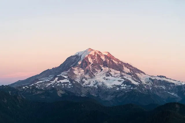
The real peaks
Genuine photographs of the summits above — so you know what to actually look for:
Sources
- Mount Rainier National Park — National Park Service
- Glaciers and Glaciology — Mount Rainier National Park, National Park Service
- Mount Rainier: Living Safely With a Volcano in Your Backyard (Fact Sheet 2008-3062) — U.S. Geological Survey
- Volcanoes and Lahars — Washington State Department of Natural Resources
- Mount Baker — Wikipedia
- Glacier Peak — Wikipedia
- Mount Rainier is shrinking (just a bit), new study finds — KUOW
- Mt Rainier Elevation Survey — Country Highpoints
- Mount Rainier — Wikipedia